National Spatial Data Infrastructure in Sri Lanka

Are you facing challenges in sharing your spatial information within your organization? Is the data inaccessible by multiple departments? Are manual data sharing processes causing delays in your business practices?

Discover how Avineon implemented National Spatial Data Infrastructures (NSDI) to create an environment where government organizations can cooperate, and thus improve, the management and sharing of spatial information!


Customer: The Information and Communication Technology Agency (ICTA) of Sri Lanka


Region / Country: Sri Lanka


Industry: Government Agencies and Organizations


Solution: Spatial Data Infrastructure


The Client: Information and Communication Technology Agency (ICTA) of Sri Lanka

The project was executed for the Information and Communication Technology Agency (ICTA) of Sri Lanka with the goal of developing a National Spatial Data Infrastructure for Sri Lanka to enable the easy sharing of spatial information within multiple departments and facilitate effective and efficient decision making based on up to date and real time evidence.

The Challenge: The Management and Sharing of Spatial Information

The government of Sri Lanka has a wealth of spatial information collected by various government departments, with the majority of data being collected by the Survey Department. This information could not easily be shared between organizations, nor was it accessible to the broader community. This means that the benefits of this information were not fully realized.


To facilitate the exchange of spatial information, nations around the world are developing National Spatial Data Infrastructures (NSDI). A NSDI is an initiative that creates an environment where government organizations can cooperate, and thus improve, the management and sharing of spatial information.

The Solution: Development of Sri Lanka NSDI GeoPortal

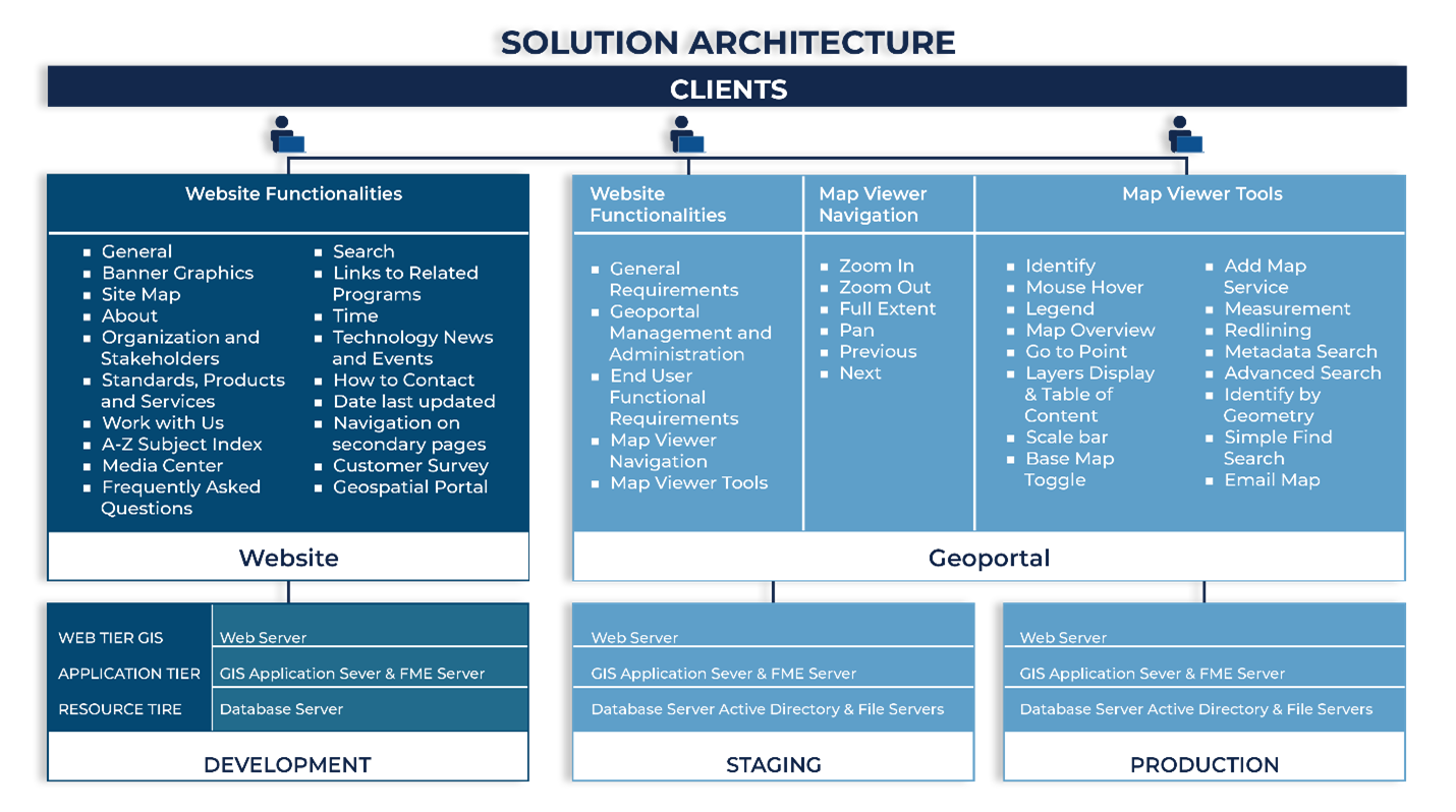
Avineon worked with ICTA to perform the following:


1) Data Modeling and Data Standards Development
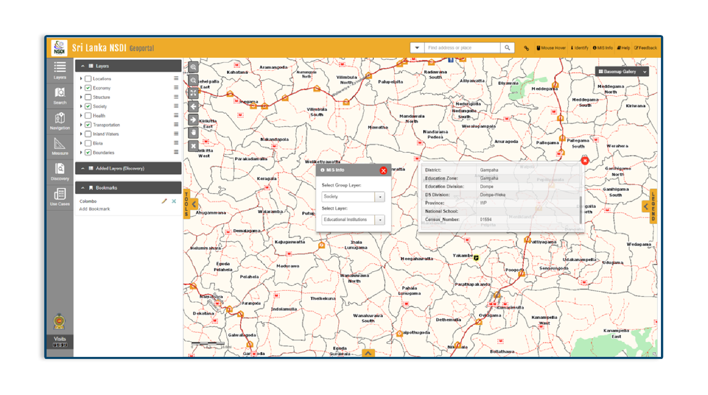
2) NSDI Geoportal Development
3) Use Case Application Development for 5 sectors: Tourism, Agriculture, Urban Development, Disaster Management, and the Archaeology Department


NSDI Solution Architecture


(Download our full case study for more details)

The Result: A GeoPortal Enabling the Easy Sharing of Spatial Information

1) The fact that the data is shared will result in data improvement, since stakeholders are demanding accurate/up-to-date/new data.


2) The availability of a technology platform enables multiple departments (without IT infrastructure) to come up with application requirements OR.


3) Multiple departments are able to consume data and develop applications on their own infrastructure.


4) Datasets with business value and cross-department usage are identified, enabling transparent and fast data sharing.


5) The SL-NSDI data model is robust and can be used to model more data layers or update the existing layers.


6) The metadata portal has the capability to both import metadata or enter/update metadata directly for both existing and future layers.


7) More data services can be created and published easily.


8) The chosen technology not only allows the development of complex applications, but also hosts it for users.


9) The chosen technology also allows to develop data loading/migration tools by using ETL tools, like FME.


NSDI_Picture 2

Want to learn more? Download the full case study!

Interested? Let's talk!