Geo-engineering and Geo-design require engineering and geospatial professionals to cooperate closely, bringing together data, technologies, and processes.
Information modelling, and Building Information Modelling (BIM) in particular, has become one of the key concepts in digital construction, particularly regarding engineering design visualization and validation, since it typically addresses key design data in the engineering space, focused on discipline / aggregated design for individual buildings.
Levering on both geospatial data and technology capabilities, Geo-enabled BIM thus unlocks new capabilities for Geo-engineering or Geo-design that go beyond individual buildings, and thus enables critical design considerations and validations across a larger area (Aggregated buildings across an area or Aggregated engineering discipline models in a large building).
GeoBIM: key decisions to make
Scenario-1: The implementation of GeoBIM for all legacy buildings and constructions that city agencies manage today. Based on the importance of the buildings, the following legacy formats can be considered:
Option 1 – 2D CAD designs to BIM to GIS
Option 2 – Paper designs to BIM to GIS
Option 3 – Existing BIMs to GIS.
Scenario-2: The implementation of GeoBIM as part of the digitalization of the building permits process for new / proposed buildings, including the online submission and automated design validation.
With many agencies still managing their designs in 2D CAD drawings, another key question relates to whether to mandatorily enforce BIM submissions for all types of buildings and contractors, or whether to allow the smaller consultants and contractors(say managing small residential constructions) to still submit 2D CAD designs, and let the administrative agencies take responsibility to validate and/or convert the same to BIM using automated tools and templates.
Some of the COTS GIS technologies are enhancing GIS/BIM integration capability by providing functionalities to directly read BIM models. However migration of BIM models to GIS database is necessary for better utilization of BIM data like publishing over web or executing custom analytical tools across multiple models etc.,
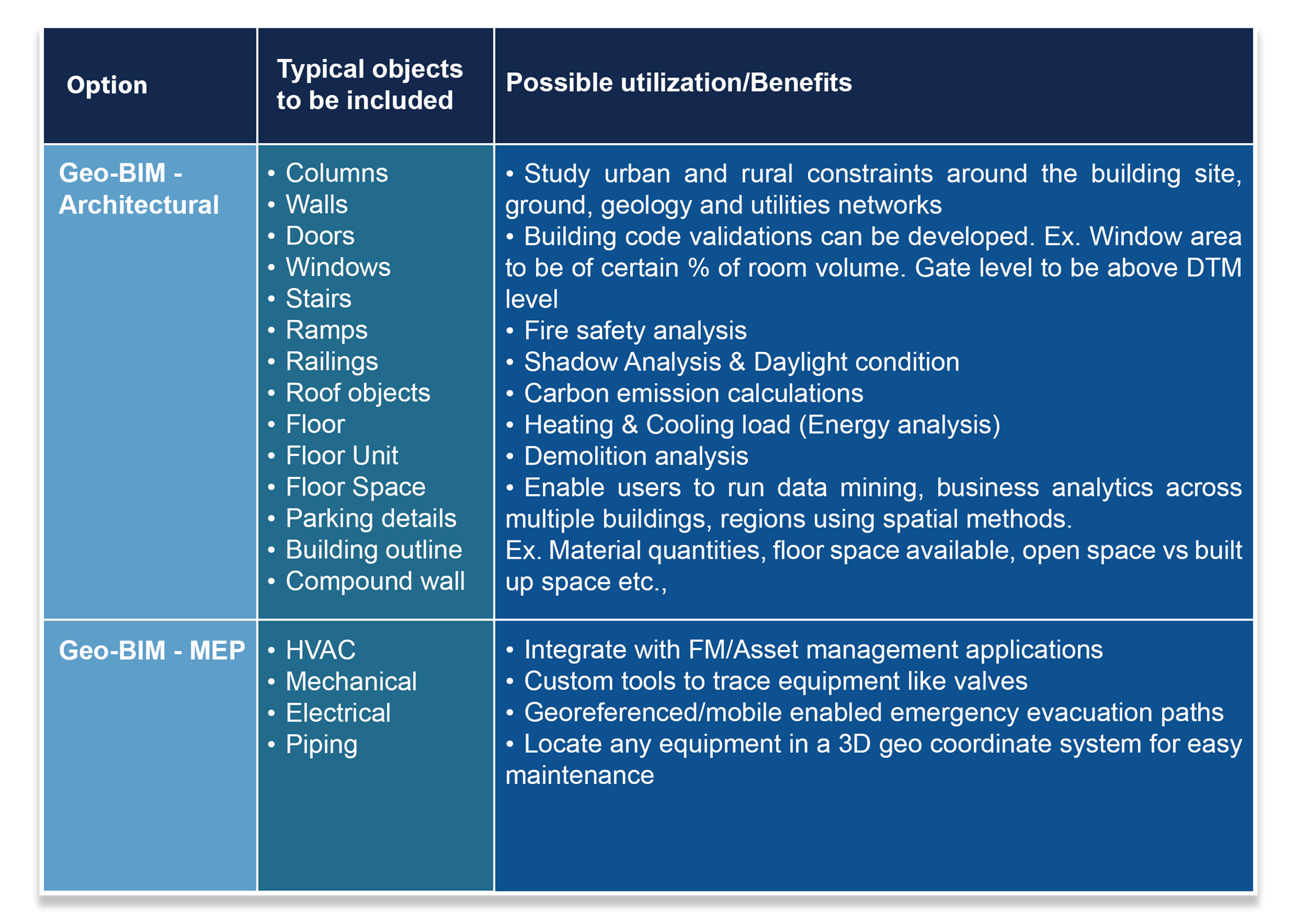
What to convert to GIS
BIM holds a lot of engineering components and details, like structural, architectural, MEP, and Elevational, according to Level of details (LOD 100 – 500) represented in the model. It is therefore important to decide on which objects or features to migrate, especially in legacy data conversion or migration. An important driver in this decision naturally is the organizations’ vision and thought process related to the intended use of the Geo-BIM datasets.
For example, if an organization envisions to integrate BIM to Facility management or Asset management, the conversion and migration of all mechanical / electrical / plumbing components will be needed. On the other hand, if an agency, for example, wants to use GeoBIM for the validation of certain building codes, the creation of use of space statistics, general energy demand calculations, building visualizations, or emergency response management, it might be sufficient to migrate key architectural components and features.
Both options have their own advantages and return on investment.
Data modeling and technology considerations
The GeoBIM modelling approach does not require to migrate all engineering discipline BIM models to GIS with all features / information. Based on the migrated elements / objects and the level of details captured, the GIS data model can adopt the BIM Institute standard data model and customize it to GIS technology requirements for the relevant BIM objects identified to be migrated to GeoBIM.
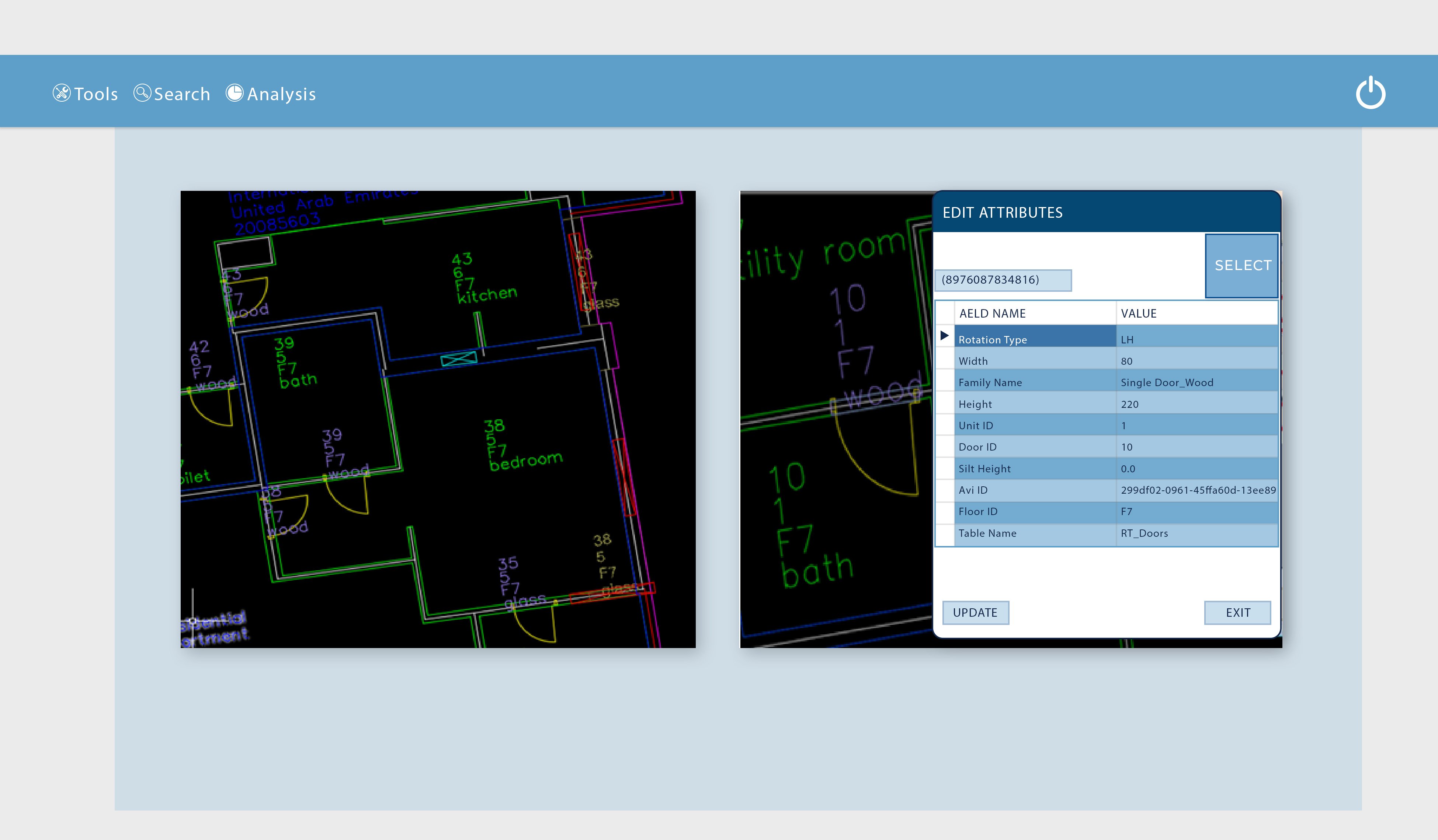
Maintaining unique feature IDs helps in integrating GeoBIM objects to external databases or in establishing feature relationships. In addition, maintaining floor relationships while migrating is important for locating, analytical purposes, bill of quantities etc.
Modelling complex elements, like stairs and railings, in a GIS system is more complex compared to BIM systems, as BIM technologies maintain these objects as complex/grouped elements. To address this challenge, and facilitate GIS databases to treat these complex elements as one, custom data models, relevant 3D GIS objects like multi-patch geometry, feature ID relationships must be used. In addition,
customized ETL tools need to be built to migrate such complex elements from the native BIM formats to the customized GIS models.
A carefully considered approach to identify the required attribute datasets, that will enable spatial analysis or integration with asset management
applications, is required when establishing the GIS for MEP elements. For a pipe, for example, the following attributes can be considered:
- Flow stream
- Diameter
- Area (cross section)
- Material
- Length
- Insulation
- Lining
- Air flow properties like: status, pressure, flow rate, flow velocity, and pressure drop
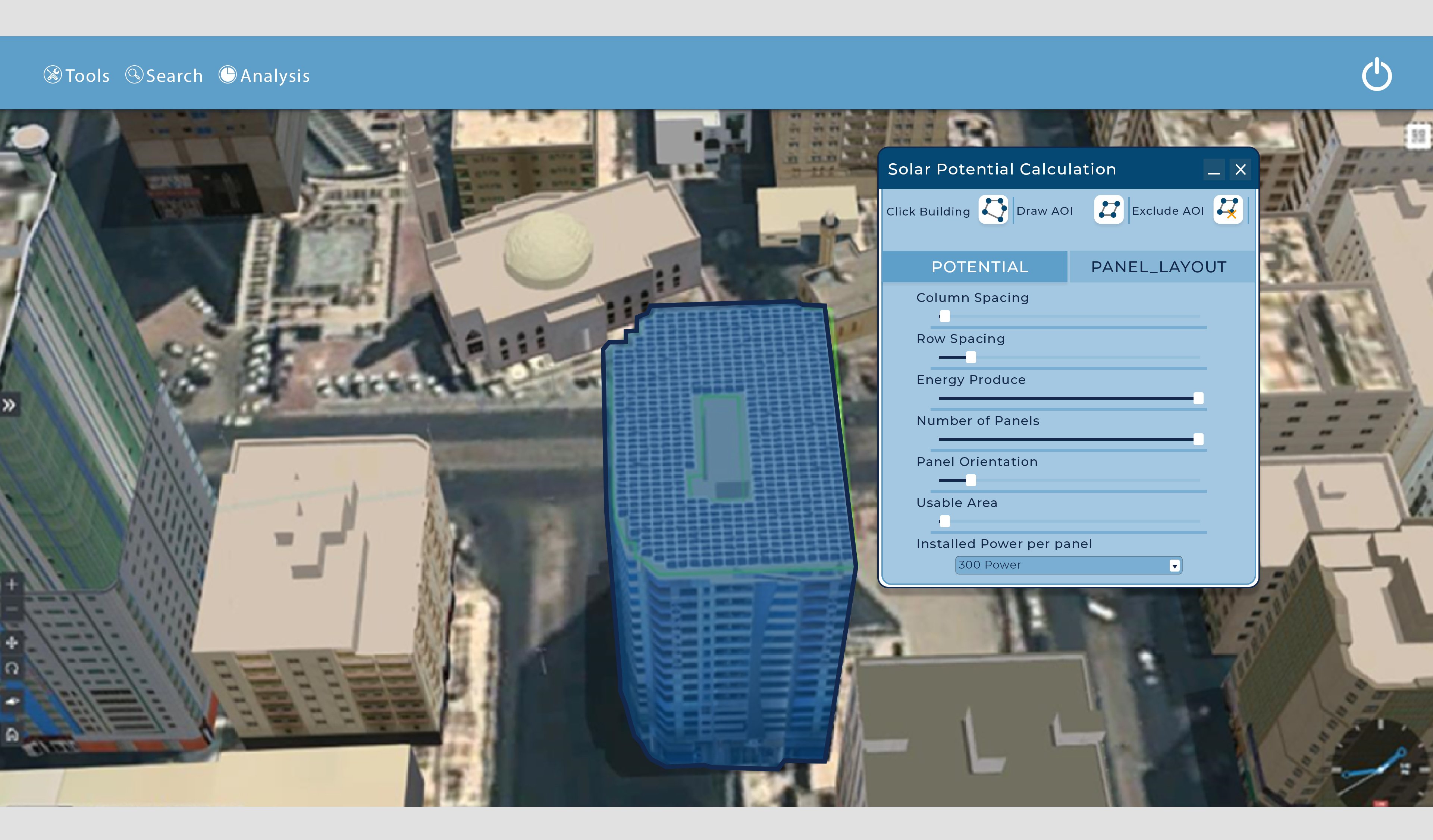
Integrated GeoBIM and 3D city model: As you may have read in Avineon ’s article on “GeoBIM: Data Formats & models for converging 3D GIS & BIM", city GML objects/buildings with real texturing can be migrated to a GIS database and published as map/scene services using GIS server technologies. 3D city layers can be overlaid on GeoBIM layers and custom applications, like roof Solar potential calculations, can be developed.
The integrated data model for BIM and 3D city models uses CityGML and 3D Vector Scene objects in GIS and can enable a high-quality visualization of textured building overlays on top of Geo-BIM models.
GeoBIM: Conversion approach
Legacy designs: CAD, Paper, BIM format
Avineon typically adopts the GeoBIM approach illustrated in figure 1. We have identified the constraints / limitations in various COTS technologies and augmented our approach with custom tools to achieve an efficient and automated CAD->BIM->GIS conversion without any data loss while maintaining data/feature integrity.
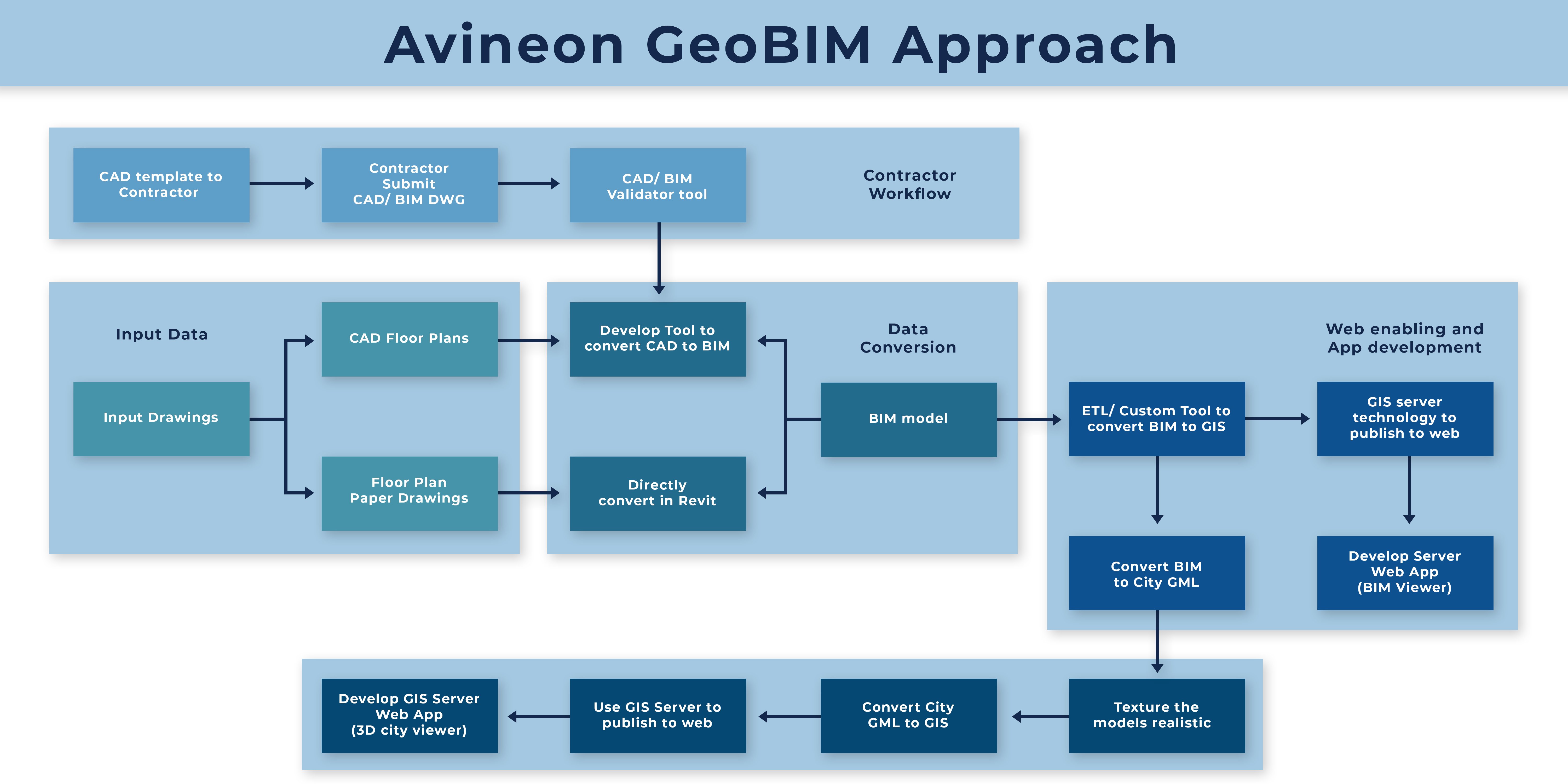
Standardizing CAD design templates is key to an efficient GeoBIM conversion process that continues to allow CAD design submissions from contractors. To enable an automated conversion, CAD templates must address attribute and BIM capture requirements, like object library (families) definition, and unique geometry capture requirements.
BIM/GIS conversion tools/technologies
Various COTS ETL tools convert BIM models to GIS with a certain level of completeness and accuracy. Open formats, like IFC, can be used to convert BIM models to GIS. However, there are constraints/short comings in terms of loss of attribute data, slow performance in data loading/reloading, publishing etc.,
We have observed that, when loading large numbers of BIM models (say a few thousands) in case of city-wide Geo BIM databases, COTS software has limitations in managing complex elements in terms of performance/speed using front end loading tools. This becomes a challenge when there is a need to load BIM models multiple times or load changes to the GeoBIM models.
As illustrated in figure 2, Avineon has derived a unique hybrid approach by utilizing COTS tools for their strengths and by developing both custom ETL tools, to load complex elements to datastores through back-end procedures, and procedures to load changes / deltas separately, ultimately providing flexibility, a higher speed and lesser downtime.
Avineon also developed/adopted custom tools to load complex elements, like stairs/ramps/railings, and attributes that got lost during COTS ETL based migration, while maintaining GIS data model integrity requirements.
GeoBIM: Web enabling
Publishing geospatially located 3D models or datasets over web is an effective way to communicate designs to a wider audience, as design options can be evaluated easily by using switchable level structures. This is one of the key purposes of GeoBIM.
GeoBIM provides an opportunity to overlay all the underground utilities and terrain data available in GIS as web services with a new building model. The integrity of this data is critical to ensure no interference occur during construction.
Client/Server based GIS technologies provide dynamic and flexible data sharing/visualization/ analysis/ hosting/access options, avoiding license overheads and software installation overheads.
Powerful APIs of GIS technologies empower decision makers with ample opportunities to develop custom tools to address various user needs and integration needs.
Ex. GIS technology APIs provide an opportunity to develop geolocation-based network tracing in the 3D space and identification and visualization tools for facility management and maintenance.
Specialized tools like Virtual Reality views, Heating / Cooling demand, Solar potential calculation, Material dashboards, Volume vs Footprint, Building code validations, Shadow analysis etc., can be developed using Geo-BIM models and aggregated over spatial regions like administrative boundaries.
Figure 3: GeoBIM integrated with 3D city model providing BOQ for a selected building over web
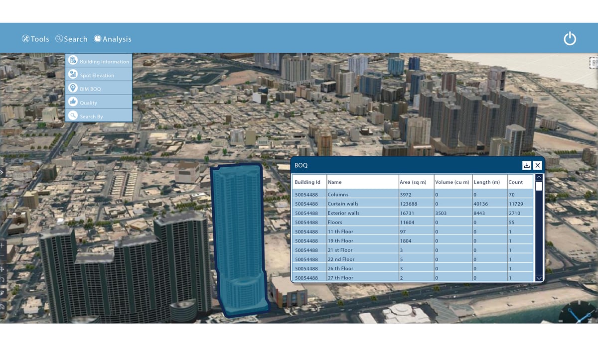
Figure 4: GeoBIM integrated with 3D city model providing solar potential for a roof over web
- Avineon has developed and implemented an end-to-end GeoBIM strategy for converting a large volume of legacy buildings for a municipal authority and brings proven and referenceable experience to its customers who aspire to develop a GeoBIM strategy to meet their business goals.
- Avineon has developed an efficient and automated approach for converting and migrating legacy CAD designs to GeoBIM databases and publish over web, with all the web portal functionalities to view, query, analyze and maintain the database and to successfully deploy the datastores in a LIVE environment. Avineon’s web-based GeoBIM viewer and custom-built value-added tools can quickly provide the targeted business value that clients aim to achieve from their GeoBIM strategy.
- Avineon also provides consultancy services to define and establish BIM standards, CAD standards, and data capture specifications, which are key for developing a successful ecosystem between suppliers, contractors, and end-users to seamlessly create and maintain GeoBIM databases and meet the organizational business and functional requirements.