
This article starts with technical topics and concludes with three best practices relevant to GIS Leadership (Architects, Supervisors, Managers, Directors, VPs, CIO, etc.) at electric, gas, water, architecture, engineering, construction (AEC), and telecommunication companies.
During a recent internal global collaboration, representatives from various offices working on ArcGIS Utility Network (UN) engagements had the opportunity to meet and share knowledge, key challenges, and best practices. These conversations included a review of differences in electric, gas, and water systems across geographies, the implementation of Subnetwork Controllers versus Batch Trace for maintaining mesh and radial network topologies - its impact on system performance, productivity, workflows, and end-user experiences, as well as the ongoing utilization of tools, technologies, procedures for implementing UN on-premises and in the cloud. The conversations also included:
- Advantages and consequences of implementing Foundation models from Esri versus tailoring them to meet business needs versus designing customer-centric custom data models.
FME patterns used for data migration to the UN, along with data integration use cases with other enterprise platforms and systems.
- Leveraging Esri's Utility Data Management Support tools to implement data quality trending dashboards in ArcGIS Enterprise at a water utility.
- Implementation of LRS for a gas distribution company.
- Internationalization (language) efforts that were essential to achieve end-user acceptance.
- Differences in the modeling of electric systems within the UN across geographies.
- Explorations into the online and offline use of web and mobile data editing tools for the UN to (a) improve user experience, (b) stay current with field conditions, and (c) contain IT infrastructure costs.
Best Practices
Among the best practices discussed, the three that stood out the most were:
- Modernization Scope
- Strategic Alignment
- Success Criteria
The lack of consensus among all stakeholders in these three areas leads to ambiguity, disproportionate allocation of enterprise resources, and delay in achieving the intended outcomes.
While it is common for companies to delve into implementation projects with many impending business and technical decisions, developing a consensus on high-level outcomes and establishing a governance model among GIS Leadership, including Architects, Supervisors, Managers, Directors, VPs, and even the CIO, is critical to:
- Rightsizing and phasing the investments for modernization.
- Mitigating risks.
- Making informed decisions for delivering intended outcomes.
Modernization Scope
The digital modernization engagements to implement ArcGIS Utility Network offer opportunities in many areas illustrated below. In particular, the level of modernization targeted in the Model with the targeted fidelity drives the overall scope, investment, and short-term and long-term benefits and, therefore, requires thorough diligence with all stakeholders. It also enables the successful delivery of transformative initiatives such as grid modernization in the electric industry, regulatory compliance in the gas industry, quality and environmental drivers in the water industry, and operational efficiencies in the communication industry.
The inclination to modernize in all areas significantly increases the risk profile. Also, the lack of clarity in the target state within each area is problematic, resulting in unnecessary spending, increased complexity, decreased usability, and excessive customizations without precise alignment to business value.
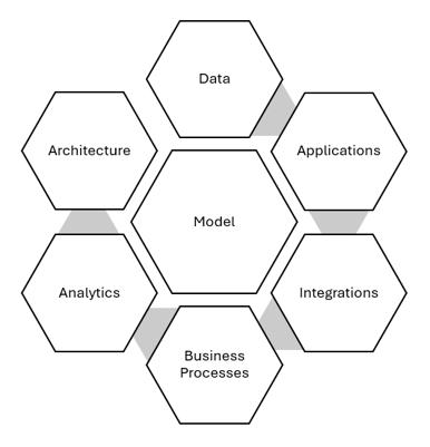
Modernization Opportunities
![]() The deliberate selection and road mapping of opportunities is critical to mitigate risks and deliver the intended outcomes for (i) safety, (ii) customer satisfaction, (iii) regulatory adherence, (iv) sustainability, (v) productivity, (vi) revenue, and (vii) stakeholder value.
The deliberate selection and road mapping of opportunities is critical to mitigate risks and deliver the intended outcomes for (i) safety, (ii) customer satisfaction, (iii) regulatory adherence, (iv) sustainability, (v) productivity, (vi) revenue, and (vii) stakeholder value.
Strategic Alignment
The intrinsic value of any Utility GIS is compounded through the extrinsic value from integrated enterprise systems for outage management, planning, forecasting, customer relationship management, work management, field workforce management, enterprise resource management, document management, analytics, etc. Aligning the Utility GIS Modernization scope and road map with the road maps of integrated systems is essential for defining pragmatic business releases and managing the outcomes for user acceptance.
In such an enterprise context, software version upgrades, and infrastructure upgrades are not isolated to GIS but rather occur in parallel.
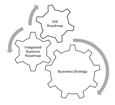
Business and IT Alignment
![]() Aligning the Utility GIS Modernization scope and road map with the road maps of integrated systems is essential for managing interdependencies and delivering business releases.
Aligning the Utility GIS Modernization scope and road map with the road maps of integrated systems is essential for managing interdependencies and delivering business releases.
Success Criteria
Modernizing Utility GIS using the UN is like a cross-country road trip with multiple stops and destinations. The flexibility to pivot and adapt is essential to circumvent the technology and business constraints beyond the implementation team's control. The phased cutover strategy and criteria to assess the arrival and departure at each stop and each destination (release of business value) are essential to confronting complexity with simplicity.
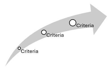
Gate Reviews - Entry and Exit Criteria
![]() A mature construct such as the Program Increment from Scaled Agile provides the governance to drive and deliver the intended outcomes.
A mature construct such as the Program Increment from Scaled Agile provides the governance to drive and deliver the intended outcomes.
In conclusion, embracing best practices is essential to mitigate risks and deliver the intended outcomes from modernizing Utility GIS, and prioritization of modernization objectives is vital for success.
Avineon, a leader in spatial intelligence, can help to assist you in your journey. We have a rich history as an Esri Partner for over 20 years, and we are experienced in delivering a complete suite of geospatial products and services to our clients in numerous industries, including utilities and local, state, and federal government agencies.
![]()