
Next Generation 911 (NG911) is a modernized emergency response system for the United States. NG911 aims to improve emergency communication capabilities by implementing new technologies, such as GIS, into the existing 911 infrastructure. ArcGIS Pro has bunch of tools integrated in their software that enable emergency response agencies to utilize GIS data for more accurate location tracking, to improve routing of emergency services, and create better situational awareness during emergency incidents. Emergency responders can access and analyze the geographic data in real-time, facilitating a faster and more effective response to emergencies.
What is NG911?
NG911 is a tool that helps to improve ways to receive and respond to 911 calls. With NG911, you no longer have to dial a phone number. Instead, you have the ability to text, send pictures, and send videos (including support for American Sign Language users) from an incident. The geographical location data is then sent to the right PSAP and they are able to pinpoint the exact location of the incident, making it easier to get help at the location as fast as possible. With NG911 there is no longer a need to determine which emergency response agency to call.
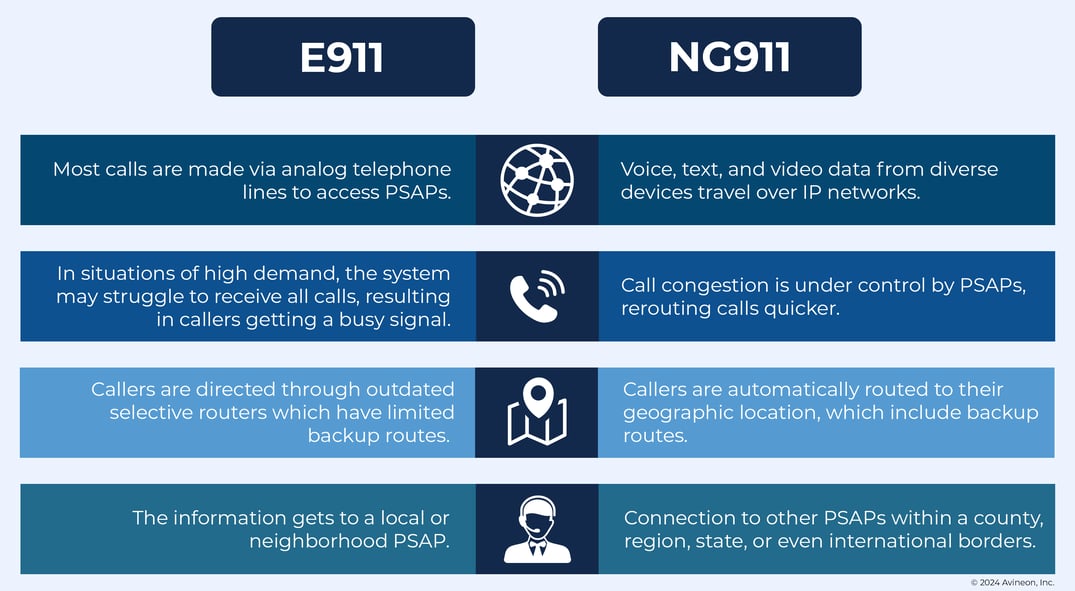
Differences between E911 and NG911
The help Avineon can offer
Transforming addressing data for NG911 and integrating it into various systems at your organization can be tough. However, there is a big upside to this task. By meeting the precise standards set by NG911 for accuracy and completeness, you can significantly enhance your organization’s operations and services to all your stakeholders and constituents. Avineon has professionals who are specialized in helping implement your data for NG911 using ArcGIS Pro. Avineon offers the three following solutions that will help your company implement your data.
Project Design and Planning: We evaluate existing data, systems, applications, and staff expertise to develop detailed project plans, database designs, and specifications. These guides will direct our implementation tasks and training activities effectively.
Implementation: In the implementation phase, Avineon begins by consolidating and enhancing your addressing and ancillary data, which involves field-based operations. Following this, we integrate, transform, and link your systems, software, and applications to optimize the utilization of your upgraded data. This process applies to both NG911 and enterprise-wide setups.
Grow Sustainably: After completing the initial implementation, we help ensure the long-term success of your enhanced data, systems, and applications. We achieve this by establishing essential maintenance resources and putting training in place. Recognizing the importance of the human factor, we provide extensive training at all organizational levels and deliver comprehensive documentation for all developed resources.
Did this spark more questions or does this fit perfectly in your company’s needs? Make sure to contact us or get more information about NG911 Addressing.
Avineon has a ton of experience helping clients with addressing data, systems, and applications. We've worked on both standalone NG-911 projects and larger, enterprise-wide solutions. We have a rich history as an Esri Partner for over 20 years, and we are experienced in delivering a complete suite of geospatial products and services to our clients in numerous industries, including utilities and local, state, and federal government agencies.
![]()