Let's work together for a greener world, by joining forces and knowledge.
Meet'Up GreenTech 2021
It is with great pride that we announce that one of our employees, Florian Allary, Project Manager, within Avineon Europe, participated in the #MeetUpGreenTech organized by GreenTech Innovation and the Ministry of Ecological Transition on October 19 & 20, 2021.
He had the honor to speak, at the round table discussing the subject of the "Fight against the artificialization of soils, an emerging sector of activity for GreenTech".
You did not see his interview ? No worry, you can find the live here :
Fighting against the artificialization of soils is a way to protect the biodiversity of our territories, by preserving natural, agricultural and forest areas, which are habitats for species. Limiting the consumption of these spaces and achieving zero net artificialization is a goal of the Biodiversity Plan launched in 2018 by the French government.
The implementation of this objective is based on Large Scale Land Cover (GE OCS) data. The GE OCS is a mapping of the territory that describes land cover and land use at a time T. By carrying out this mapping on regular time steps, we can measure the artificialization of the soils and its evolution. It is a first-rate tool for evaluating and guiding public policy.
Avineon was selected by the IGN to produce the OCS GE database on four departments in France, Occitanie: Hérault (34), Pyrénées Orientales (66), Aude (11) and Gard (30). The Large Scale (1:2000) database was produced with metric accuracy, based on aerial images and IGN pre-processed data. These data provided an initial indication of land cover and land use.
Avineon’s task was to create the final database by photo-interpretation.
The values are defined in the national two-dimensional nomenclature, one for land cover and one for land use.
Photo-interpretation required an analysis of the landscape and the context visible on the aerial images, in order to be able to interpret land use (residential land, agricultural land, public utility networks, etc.) and land cover (paved surface, unprocessed surface, grassy areas, forests, etc.) External data were used to support the analysis.
The complexity of the project lay in the diversity and variations of landscapes on the French territory. Avineon had to learn to identify and control this great diversity in land cover and use. In addition, understanding the context was critical to correctly interpret the aerial images. During the project, new types of contexts were identified, corresponding to local characteristics.
Thanks to the close collaboration between our teams in France and India, Avineon was able to easily manage the difficulties. Avineon produced this Large Scale database with over 700,000 polygons within 10 months, for a project duration of approximately 24,500 production hours.
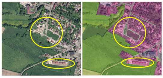
Example: measuring urban sprawl.
We are on the outskirts of a small town, on the border between urban neighbourhoods and pastures.
The illustration below shows on the left an aerial photo and on the right the same aerial photo on which the OCS GE mapping has been superimposed. Agricultural areas appear yellow-green and artificial areas appear purple. It’s a description of the territory at a precise moment T.
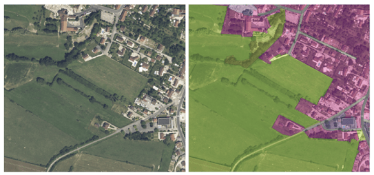
The illustration below shows the same space at the time T+1. The yellow circles indicate the artificial zones between the T-moment and the T+1-moment. These are agricultural zones that have become residential. Two hectares of agricultural meadows have been artificialized by urban sprawl.